Sources of photography
Street View photos come from two sources, Google and our contributors.
Our Content
Google-owned content credits “Street View” or “Google Maps.” We automatically blur faces and license plates in our imagery.

Content from other contributors
User-contributed content accompanies a clickable/tappable account name, and in some cases, a profile photo.
How Google brings you Street View
To share Street View imagery, our engineering team is hard at work behind the scenes. Here’s a glimpse into what the team is doing to bring Street View to you.
-
STEP 1
Collecting imagery
First off we need to actually drive around and photograph the locations to show in Street View. We pay close attention to many factors, including the weather and the population density of various areas, to determine when and where we can collect the best possible imagery.
-
STEP 2
Aligning imagery
To match each image to its geographic location on the map, we combine signals from sensors on the car that measure GPS, speed and direction. This helps us reconstruct the car’s exact route, and even tilt and realign images as needed.
-
STEP 3
Turning photos into 360 photos
To avoid gaps in the 360 photos, adjacent cameras take slightly overlapping pictures, and then we ‘stitch’ the photos together into a single 360 degree image. We then apply special image processing algorithms to lessen ‘seams’ and create smooth transitions.
-
STEP 4
Showing you the right image
How quickly the car’s three lasers reflect off surfaces tells us how far a building or object is, and enables us to construct 3D models. When you move to an area in the distance, the 3D model determines the best panorama to show you for that location.
-
STEP 1
Collecting imagery
First off we need to actually drive around and photograph the locations to show in Street View. We pay close attention to many factors, including the weather and the population density of various areas, to determine when and where we can collect the best possible imagery.
-
STEP 2
Aligning imagery
To match each image to its geographic location on the map, we combine signals from sensors on the car that measure GPS, speed and direction. This helps us reconstruct the car’s exact route, and even tilt and realign images as needed.
-
STEP 3
Turning photos into 360 photos
To avoid gaps in the 360 photos, adjacent cameras take slightly overlapping pictures, and then we ‘stitch’ the photos together into a single 360 degree image. We then apply special image processing algorithms to lessen ‘seams’ and create smooth transitions.
-
STEP 4
Showing you the right image
How quickly the car’s three lasers reflect off surfaces tells us how far a building or object is, and enables us to construct 3D models. When you move to an area in the distance, the 3D model determines the best panorama to show you for that location.
Where we're headed
We are driving through many countries with the Street View car to bring you imagery that enhances your experience and helps you discover the world around you. Take a look at the list of countries where we are driving or Trekking next.
| Region | District | Time |
|---|---|---|
| {[value.region]} | {[value.districts]} | {[value.datestart| date:'MM/yyyy']} - {[value.dateend| date:'MM/yyyy']} |
Because of factors outside our control (weather, road closures, etc), it is always possible that our cars may not be operating, or that slight changes may occur. Please also be aware that where the list specifies a particular city, this may include smaller cities and towns that are within driving distance.
Where we’ve been
The blue areas on the map show where Street View is available. Zoom in for greater detail, or browse this content with our websites and apps.
Google’s own Street View fleet
Browse through our Street View fleet.
-
Street View Car
We’ve come a long way since our initial U.S. launch in 2007; today we’ve expanded our 360 photos to include locations on all seven continents.
-
Street View Trekker
The Trekker enables Street View to feature more places around the world — places no car, trike, trolley or snowmobile can access. This wearable backpack is outfitted with a camera system on top, and its portability enables us to gather images while maneuvering through tight, narrow spaces or locations only accessible by foot. Our first collection using this camera technology was taken along the rough, rocky terrain of Arizona’s Grand Canyon.
-
Street View Trolley
When a group of art-loving Googlers wanted to take Street View technology to museums around the world, we needed to develop a system that could easily fit through museum doorways and navigate around sculptures. This first foray indoors fit all the necessary equipment onto a smaller frame: a push-cart mounted with a camera system dubbed the Trolley. It has not only collected views from inside museums, but also other indoor locations like the White House and sports stadiums.
-
Street View Snowmobile
Another place we thought it’d be fun to take the Street View cameras are on the slopes. Over a few weekends using some 2x4s, duct tape, and extra hard drives wrapped in ski jackets to endure the freezing conditions, the team was able to successfully mount the Street View equipment on a snowmobile. Skiers, snowboarders and snowshoers can now explore Whistler Blackcomb Mountain and the hilly, snow-capped terrain shared by surrounding resorts.
-
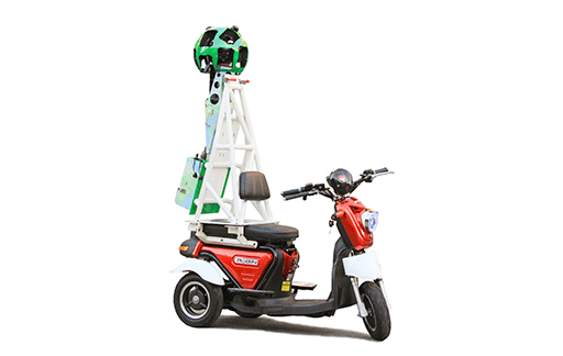
Street View Three-Wheeler
For cities with small streets we had to think of a vehicle strong enough to hold the Street View trekker. In order to reach some of the narrow alleyways, our team found out that motorcycle Selis Robin in Indonesia is a great solution. Meet the Street View three-wheeler. Additional mast has been built specifically for this vehicle to provide additional stability for the Street View trekker.